Message from NOAA National Hurricane Center
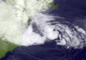
Hurricane Sandy is centered this morning about 265 miles southeast of Atlantic city, New Jersey. It is now moving toward the north-northwest. A turn toward the northwest is expected later this morning, then west-northwest tonight. That will bring the center over the mid-Atlantic coast this evening or tonight. Do not focus on the exact center of landfall as impacts will be felt over a large area.
Hurricane Sandy strengthened a little this morning, and is forecast to bring life-threatening storm surge flooding to the mid-Atlantic coast, including Long Island Sound and New York Harbor, as well as coastal hurricane-force winds…and even heavy Appalachian snow.
Maximum sustained winds are 85 mph – a Category One hurricane on the Saffir-Simpson Hurricane Wind Scale. Sandy is expected to transition into a frontal or wintertime low pressure area before landfall, but is not expected to weaken during that transition. In fact, it may strengthen during this process. It will not weaken until after moving inland.
Tropical-storm-force conditions or gale-force winds are already occurring along portions of the mid-Atlantic coastline, and will spread northward through this morning.
Hurricane-force winds are expected along the coast from Chincoteague, Virginia, to Chatham, Massachusetts. This includes the tidal Potomac from Cobb Island to Smith Point, the middle and upper Chesapeake Bay, Delaware Bay, the coast of the northern Delmarva Peninsula, New Jersey, the New York City area, Long Island, Connecticut and Rhode Island. Winds affecting the upper-floors of high rise buildings will be significantly higher than those near ground level.
A dangerous storm surge is expected to occur in the mid-Atlantic states and southern New England. If the peak surge occurs at the time if high tide, the depths above ground level could reach 6 to 11 feet at Long Island Sound and Raritan Bay, and 4 to 8 feet from Ocean City, Md., to the Connecticut/Rhode Island state line, and 3 to 6 feet from there to the south shore of Cape Cod, including Buzzards Bay and Narragansett Bay.
A Tropical Storm Warning continues along the North Carolina coast from north of Surf City to Duck, including Pamlico and Albemarle Sounds, as well as Bermuda.
Other coastal and inland watches and warnings are in effect for much of the mid-Atlantic states and New England. See the statements being issued by local National Weather Service offices, www.weather.gov for the details.
Total rainfall amounts of 3 to 6 inches, with isolated 8 inch amounts, are possible over far eastern North Carolina. Amounts of 4 to 8 inches, with isolated 12 inch amounts, are possible over portions of the mid-Atlantic States, including the Delmarva Peninsula. Amounts of 1 to 3 inches, with isolated 5 inch amounts, are possible across southern New York through New England.
Snow accumulations of 2 to 3 feet are expected in the mountains of West Virgina, with locally higher amounts, tonight through Tuesday Night. The southwestern Virginia mountains are forecast to see 1 to 2 feet of snow, with 12 to 18 inches near the North Carolina/Tennessee state line and in the mountains of western Maryland.
Get the latest on this tropical cyclone, including storm surge information and graphics, on the NOAA NHC website at www.hurricanes.gov


